Full directions

Click below for a pdf including stage-by-stage details of the route with photos and a map, as well as links to car parks and public transport. A walking app GPX is also available.
Walk details
Length: 8mls | Av. time: 3.35hr | Ascent: 892ft
Start: Ashford in the Water | Google Map
Walk description, map & GPX | Download
Starting from the picture-postcard village of Ashford-in-the-Water, this fairly easy 8-mile walk takes in a short stretch of the Monsal Trail before dropping down from Headstone Viaduct to the picturesque banks of the River Wye.
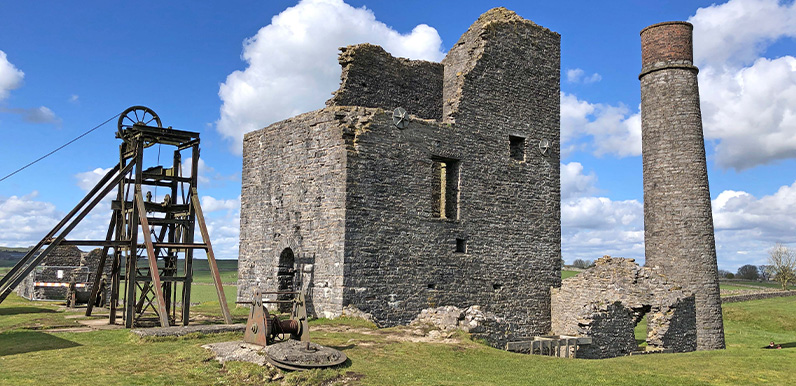
Parts of the riverside path can get muddy after rain, so walking boots are recommended. The walk then crosses the busy A6 before reaching Deep Dale, and on to the ruins of Magpie Mine; the last working lead mine in Derbyshire and the scene of a famous triple murder in 1833.

Above: A display board behind the square chimney tells the history of the mine (click to enlarge), including brief details of the murders. (The perpetrators were acquitted on a technicality.)
From the mine, it’s a short walk across fields to reach Sheldon. The wonderfully-named Cock and Pullet pub is always worth a visit and has a few outside benches at both the front and rear.
There are two options for the return to Ashford; either through Little Shacklow Wood where you pass the blocked off entrances to a number of mines. Or the more scenic route to the right of the trees – which is the one I’ve described.
There are two pubs in Ashford; The Bulls Head and the recently-reopened Ashford Arms. There’s a also a tea room beside the church.
Route photos
Stages 1-6 of the route. Click any to enlarge and scroll through.
Relive video
Click to play and use the expand option to view in full-screen. More Monsal Trail Relives.