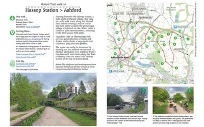
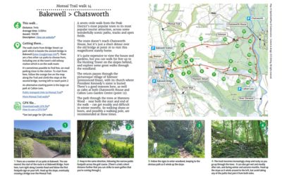
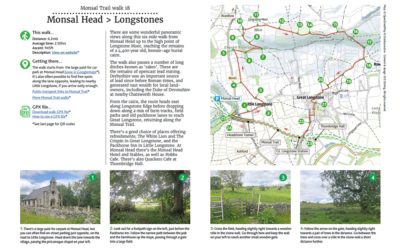
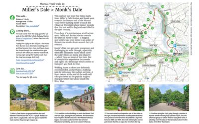
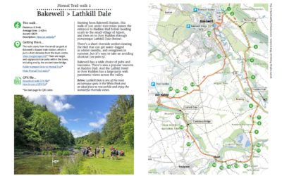
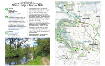
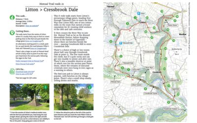
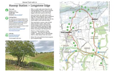
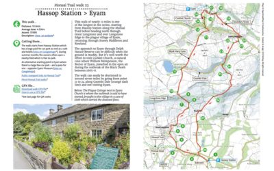
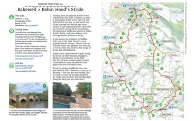
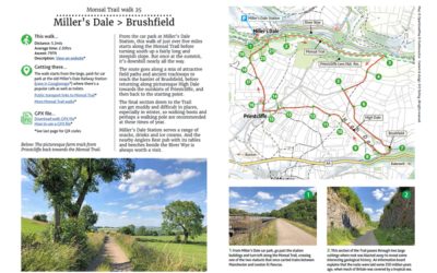
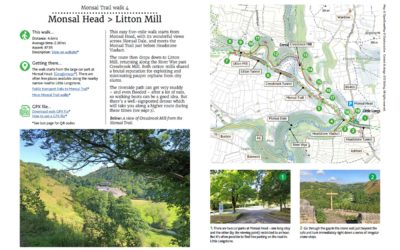
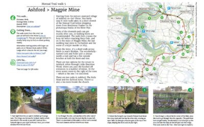
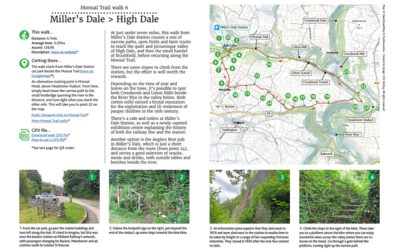
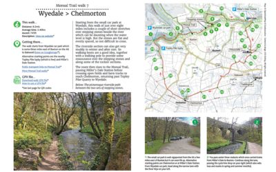
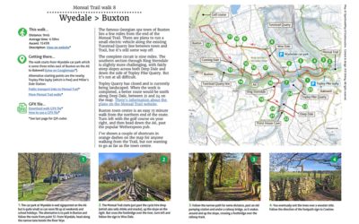
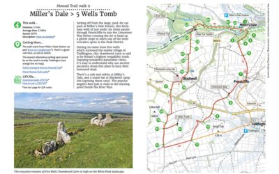
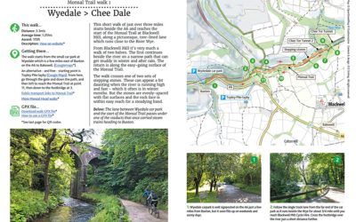
Pages: Walk guides...

1. Wyedale > Chee Dale

1. Wyedale > Chee Dale

Distance: 3.3mls
Average time: 1.25hrs
Ascent: 115ft
Description: Click to view

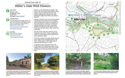
Download a two-page A4 pdf of the route including detailed instructions, photos and map. A GPX file is also available to follow the route in any walking app. Simply select from the dropdown below…

10. Hassop Station > Ashford

10. Hassop Station > Ashford

Distance: 6mls
Average time: 2.30hrs
Ascent: 292ft
Description: Click to view

Download a 3-page A4 pdf of the route including detailed instructions, photos and map. A GPX file is also available to follow the route in any walking app. Simply select from the dropdown below…

11. Monsal Head > Ashford

11. Monsal Head > Ashford

Distance: 4.9mls
Average time: 2.15hrs
Ascent: 787ft
Description: Click to view

Download a 3-page A4 pdf of the route including detailed instructions, photos and map. A GPX file is also available to follow the route in any walking app. Simply select from the dropdown below…

12. Topley Pike > Wormhill

12. Topley Pike > Wormhill

Distance: 4.9mls
Average time: 2.15hrs
Ascent: 787ft
Description: Click to view

Download a 3-page A4 pdf of the route including detailed instructions, photos and map. A GPX file is also available to follow the route in any walking app. Simply select from the dropdown below…

13. Bakewell > Rowsley

13. Bakewell > Rowsley

Distance: 8.1mls
Average time: 3.25hrs
Ascent: 886ft
Description: Click to view

Download a 3-page A4 pdf of the route including detailed instructions, photos and map. A GPX file is also available to follow the route in any walking app. Simply select from the dropdown below…

14. Bakewell > Chatsworth

14. Bakewell > Chatsworth

Distance: 7mls
Average time: 3.05hrs
Ascent: 1063ft
Description: Click to view

Download a 3-page A4 pdf of the route including detailed instructions, photos and map. A GPX file is also available to follow the route in any walking app. Simply select from the dropdown below…

15. Miller’s Dale > Tideswell

15. Miller’s Dale > Tideswell

Distance: 7.3mls
Average time: 3.15hrs
Ascent: 860ft
Description: Click to view

Download a 3-page A4 pdf of the route including detailed instructions, photos and map. A GPX file is also available to follow the route in any walking app. Simply select from the dropdown below…

16. Hassop Station > Bakewell

16. Hassop Station > Bakewell

Distance: 3.9mls
Average time: 1.35hrs
Ascent: 299ft
Description: Click to view

Download a 3-page A4 pdf of the route including detailed instructions, photos and map. A GPX file is also available to follow the route in any walking app. Simply select from the dropdown below…

17. Ashford > Churchdale

17. Ashford > Churchdale

Distance: 3mls
Average time: 1.15hrs
Ascent: 171ft
Description: Click to view

Download a 3-page A4 pdf of the route including detailed instructions, photos and map. A GPX file is also available to follow the route in any walking app. Simply select from the dropdown below…

18. Monsal Head > Longstones

18. Monsal Head > Longstones

Distance: 6.2mls
Average time: 2.50hrs
Ascent: 945ft
Description: Click to view

Download a 3-page A4 pdf of the route including detailed instructions, photos and map. A GPX file is also available to follow the route in any walking app. Simply select from the dropdown below…

19. Miller’s Dale > Monk’s Dale

19. Miller’s Dale > Monk’s Dale

Distance: 5.6mls
Average time: 2.50hrs
Ascent: 883ft
Description: Click to view

Download a 3-page A4 pdf of the route including detailed instructions, photos and map. A GPX file is also available to follow the route in any walking app. Simply select from the dropdown below…

2. Bakewell > Lathkill Dale

2. Bakewell > Lathkill Dale

Distance: 8.8mls
Average time: 3.40hrs
Ascent: 682ft
Description: Click to view

Download a 2-page A4 pdf of the route including detailed instructions, photos and map. A GPX file is also available to follow the route in any walking app. Simply select from the dropdown below…

20. White Lodge > Monsal Dale

20. White Lodge > Monsal Dale

Distance: 5.5mls
Average time: 2.30hrs
Ascent: 604ft
Description: Click to view

Download a 3-page A4 pdf of the route including detailed instructions, photos and map. A GPX file is also available to follow the route in any walking app. Simply select from the dropdown below…

21. Litton > Cressbrook Dale

21. Litton > Cressbrook Dale

Distance: 7.9mls
Average time: 3.50hrs
Ascent: 1348ft
Description: Click to view

Download a 3-page A4 pdf of the route including detailed instructions, photos and map. A GPX file is also available to follow the route in any walking app. Simply select from the dropdown below…

22. Hassop > Longstone Edge

22. Hassop > Longstone Edge

Distance: 4.5mls
Average time: 1.55hrs
Ascent: 518ft
Description: Click to view

Download a 3-page A4 pdf of the route including detailed instructions, photos and map. A GPX file is also available to follow the route in any walking app. Simply select from the dropdown below…

23. Hassop Station > Eyam

23. Hassop Station > Eyam

Distance: 10.8mls
Average time: 4.50hrs
Ascent: 1598ft
Description: Click to view

Download a 4-page A4 pdf of the route including detailed instructions, photos and map. A GPX file is also available to follow the route in any walking app. Simply select from the dropdown below…

24. Bakewell > Robin Hood’s Stride

24. Bakewell > Robin Hood’s Stride

Distance: 13.8mls
Average time: 6.15hrs
Ascent: 1739ft
Description: Click to view

Download a 4-page A4 pdf of the route including detailed instructions, photos and map. A GPX file is also available to follow the route in any walking app. Simply select from the dropdown below…

25. Miller’s Dale > Brushfield

25. Miller’s Dale > Brushfield

Distance: 5.2mls
Average time: 2.30hrs
Ascent: 797ft
Description: Click to view

Download a 4-page A4 pdf of the route including detailed instructions, photos and map. A GPX file is also available to follow the route in any walking app. Simply select from the dropdown below…

26. Miller’s Dale Wild Flowers

26. Miller’s Dale Wild Flowers

Distance: 2.1mls
Average time: 1.10hrs
Ascent: 531ft
Description: Click to view

Download a 2-page A4 pdf of the route including detailed instructions, photos and map. A GPX file is also available to follow the route in any walking app. Simply select from the dropdown below…

27. Topley Pike > Tunstead

27. Topley Pike > Tunstead

Distance: 8.1mls
Average time: 3.50hrs
Ascent: 1253ft
Description: Click to view

Download a 4-page A4 pdf of the route including detailed instructions, photos and map. A GPX file is also available to follow the route in any walking app. Simply select from the dropdown below…

3. Monsal Head > Monsal Dale

3. Monsal Head > Monsal Dale

Distance: 1.6mls
Average time: 0.45hrs
Ascent: 246ft
Description: Click to view

Download a 4-page A4 pdf of the route including detailed instructions, photos and map. A GPX file is also available to follow the route in any walking app. Simply select from the dropdown below…

4. Monsal Head > Litton Mill

4. Monsal Head > Litton Mill

Distance: 4.6mls
Average time: 2.30hrs
Ascent: 873ft
Description: Click to view

Download a 3-page A4 pdf of the route including detailed instructions, photos and map. A GPX file is also available to follow the route in any walking app. Simply select from the dropdown below…

5. Ashford > Magpie Mine

5. Ashford > Magpie Mine

Distance: 8mls
Average time: 3.35hrs
Ascent: 892ft
Description:  Click to view

Download a 3-page A4 pdf of the route including detailed instructions, photos and map. A GPX file is also available to follow the route in any walking app. Simply select from the dropdown below…

6. Miller’s Dale > High Dale

6. Miller’s Dale > High Dale

Distance: 6.mls
Average time: 3.25hrs
Ascent: 1263ft
Description: Click to view

Download a 3-page A4 pdf of the route including detailed instructions, photos and map. A GPX file is also available to follow the route in any walking app. Simply select from the dropdown below…

7. Wyedale > Chelmorton

7. Wyedale > Chelmorton

Distance: 8.2mls
Average time: 3.40hrs
Ascent: 745ft
Description: Click to view

Download a 3-page A4 pdf of the route including detailed instructions, photos and map. A GPX file is also available to follow the route in any walking app. Simply select from the dropdown below…

8. Wyedale > Buxton

8. Wyedale > Buxton

Distance: 9mls
Average time: 4.10hrs
Ascent: 1345ft
Description: Click to view

Download a 3-page A4 pdf of the route including detailed instructions, photos and map. A GPX file is also available to follow the route in any walking app. Simply select from the dropdown below…

9. Miller’s Dale > 5 Wells Tomb

9. Miller’s Dale > 5 Wells Tomb

Distance: 5.7mls
Average time: 2.40hrs
Ascent: 827ft
Description: Click to view

Download a 4-page A4 pdf of the route including detailed instructions, photos and map. A GPX file is also available to follow the route in any walking app. Simply select from the dropdown below…